Most San Diego hikers have a short list. Potato Chip Rock. Cowles Mountain. Iron Mountain on a good day. And there’s nothing wrong with any of those — but if you’re itching to get off the beaten path and into something that actually feels like a real mountain adventure, it’s time to talk about Corte Madera.
Tucked deep in the Pine Creek Wilderness inside Cleveland National Forest, Corte Madera Mountain is the kind of hike that earns its views. We’re talking a sheer 500-foot cliff face that’s earned it the nickname San Diego’s Half Dome, 360-degree summit views that stretch from downtown San Diego all the way into Baja California, and a trail that’s quiet enough that you might not see another soul. Oh, and it’s also one of the six peaks in the San Diego Six-Pack of Peaks challenge — so if you’re working on that list, this one’s a must.
Here’s everything you need to know before you go.
Table of Contents
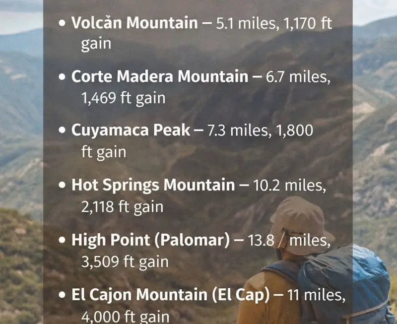
⛰ Trail Stats at a Glance
- Distance: ~7 miles out-and-back
- Elevation Gain: ~1,700 ft
- Summit Elevation: 4,659 ft
- Difficulty: Strenuous
- Time: 4–5 hours
- Dogs: Yes, on leash
- Permit Required: No permit, but an Adventure Pass is required for parking ($5/day)
- Best Seasons: Fall, Winter, Spring
- Cell Service: Sketchy at best — download your map before you go
Why Corte Madera Stands Out
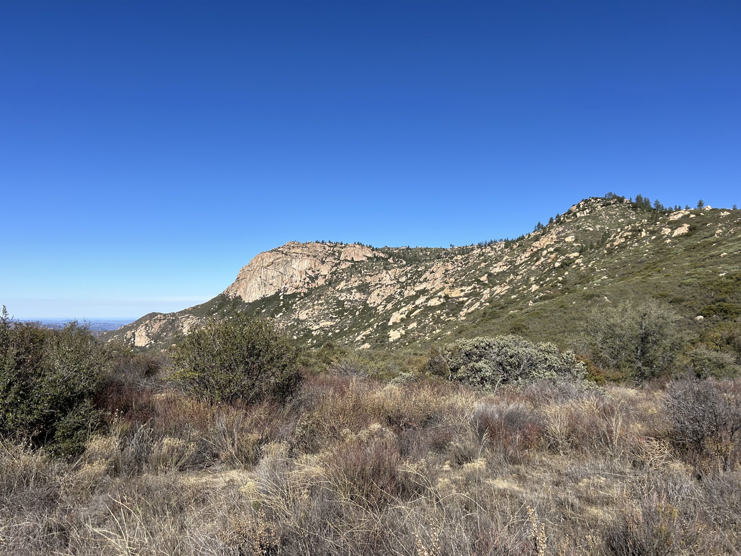
San Diego is full of good hikes, but Corte Madera Mountain hits differently. For starters, that cliff face — often visible from the saddle partway through the hike — is genuinely dramatic. It looks like something you’d see in Yosemite, not 90 minutes from the 8 freeway.
The name “Corte Madera” translates to woodyard in Spanish, a nod to this area being used as a timber source during the construction of the San Diego missions. There’s some real history out here, and the landscape shows it — dense coast live oaks, massive manzanita, Coulter pines, and colorful granite boulders scattered across the hillsides.
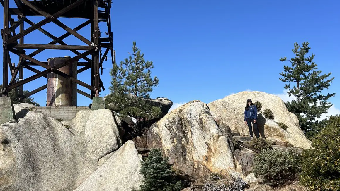
What also makes this hike special is the solitude. The combination of a long drive, a few miles of rough dirt road, and limited parking keeps the crowds way down. You’re not going to be stuck in a line at the summit. You’re going to sign the register in the old ammo box and have a moment to yourself — which is rare in this county.
One more thing: raptors. The sheer cliff face is home to prairie falcons, peregrine falcons, and golden eagles. If you’re hiking in spring, Cleveland National Forest may have seasonal closures on the cliff itself for nesting (this affects rock climbers, not hikers), so it’s worth a quick call to the ranger station at 858-673-6180 before you head out.
Getting to the Trailhead
Plan on about an hour from central San Diego. You’ll be heading east on I-8 toward the backcountry, and the last few miles of the drive are on a mix of paved and dirt road — passable by most cars, but go slow and watch for potholes.
Trailhead Coordinates: Enter Corte Madera Mountain Trail into your smart map of choice.
Parking: There’s a small sandy lot just past the hairpin turn on the left — fits about 5–6 cars. A few additional spots are available further up the road. Display your Adventure Pass on your windshield. Daily passes are $5 and can be purchased from multiple vendors — check the Cleveland National Forest website for locations near you.
Pro tip: This is remote backcountry. No bathrooms, no water, no services. Stop at the Buckman Springs rest stop on the freeway if needed, and make sure you’re topped off on water before you hit the dirt road.
Trail Guide: Step by Step
Section 1: The Locked Gate to Espinosa Trail Junction (~0.5 miles)
The hike starts at the locked gate on Keran Road. Don’t let the word “road” fool you — this first stretch is one of the prettiest parts of the whole hike. You’ll be walking through a canopy of dense coast live oaks, the trail wide and easy underfoot, with a gentle uphill grade that barely registers. It’s a great warmup.
After about a half mile, keep an eye out for the Espinosa Trail sign — there’s usually a metal garbage can marking the junction. Take the trail here to the left. The road past this point enters private property, so don’t skip this turn. This is where the real trail begins.
Section 2: Espinosa Trail to the Saddle (~1.3 miles)
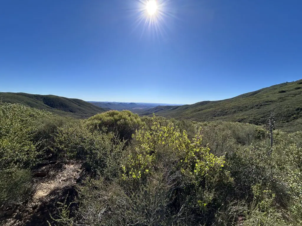
The Espinosa Trail starts a moderate, steady climb toward the saddle between Los Pinos Mountain and Corte Madera. The oak canopy gives way to classic San Diego chaparral — manzanita, scrub oak, and lots of open sky. The trail follows Morena Creek for a stretch (may be dry depending on the season).
This section is trail work — a consistent uphill that’ll get your legs warmed up without anything too brutal. The footing is generally good. At around 1.3 miles from the trailhead, you’ll pop up onto the main saddle, and this is a moment. You’ll get your first full look at Corte Madera’s dramatic cliff face looming to the north. There should also be signs here pointing to Los Pinos Peak (left), Espinosa Trail (straight), and Corte Madera (right).
Take it in. If it’s a clear day, you might already be catching views of San Diego in the distance. This saddle is a good spot for a quick water break before the next push.
Section 3: The Saddle to the Base of the Summit Trail (~1 mile)
From the saddle, head north on Los Pinos Road. This is an active dirt road, so be aware you may share it briefly with dirt bikes or OHV vehicles. It’s wide and easy walking though. Look for a forest service sign reminding you about the raptor nesting area on the cliff — and actually look up, because you’ll likely see something impressive circling overhead.
The road dead ends at a small area with some additional parking. This is where the road becomes a single-track use trail heading toward the summit. The terrain starts to shift here — you’ll start encountering granite boulders, Coulter pines, and the trail gets notably more rugged.
Section 4: The Summit Push — Use Trail to the Top (~1.2 miles)
This is where the hike earns its “strenuous” rating. The use trail conditions vary from decent to rough, so watch your footing. You’ll be weaving through chaparral and boulders on a route that’s not always obvious — this is a great reason to download the AllTrails map or a GPS track before you leave home.
The trail wraps around a small peaklet before dropping down briefly — this is probably the trickiest section. There’s a short, steep scramble to navigate around some rocky terrain. It’s not technical climbing, but you’ll use your hands for balance. Take your time here.
Past the peaklet, you’ve got about another mile to the top, weaving through more boulders and brushy chaparral. The views keep getting better as you climb. Eventually, you’ll reach a large cluster of boulders — that’s the summit.
Look for the register in an old ammo box. Sign it. You earned it.
The Summit (4,659 ft)
The summit of Corte Madera Mountain is everything you came for. On a clear day, the views are absolutely massive — downtown San Diego to the west (you can sometimes spot Point Loma), Baja California to the south, Anza Borrego to the east, and a full parade of familiar San Diego peaks: El Cajon Mountain, Mount Woodson, Cuyamaca Peak, Palomar Mountain. If there’s snow on San Gorgonio, you might even pick that out on the horizon.
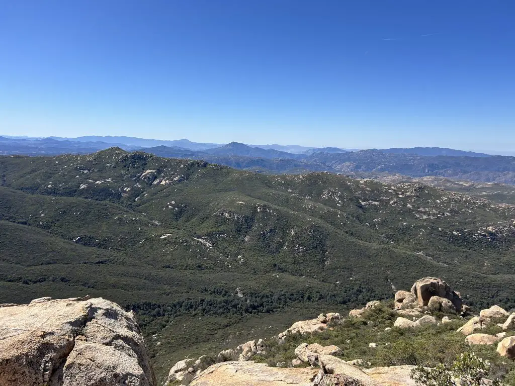
There are plenty of boulder perches to sit on and soak it in. This is a great spot to eat lunch before turning back the way you came.
What to Expect: Time, Season & Conditions
How Long Does It Take?
Budget 4–5 hours for the full out-and-back, including time at the summit. Faster hikers in good shape can do it in under 4 hours. If you’re adding the optional side trip to the Los Pinos fire tower, tack on another 1.5–2 hours (it adds roughly 4 miles).
Best Time of Year
The best windows for Corte Madera are fall (October–November), winter (December–February), and spring (March–April). Winter is particularly great — the temps are comfortable, the chaparral is green after rains, and on a clear day the visibility from the summit is jaw-dropping.
Avoid summer. The backcountry east of the mountains gets legitimately hot — temperatures in the 90s and above are common, and there’s no shade on the upper trail. This is not a summer hike unless you’re starting before sunrise.
Water & Gear
Bring at least 2 liters of water per person — there’s no water on trail. Trail runners or hiking boots both work well. Trekking poles are helpful, especially on the rocky descent. Layers are smart in winter as the summit can be noticeably cooler and windy. And since cell service is essentially nonexistent, bring a satellite communicator or at minimum a downloaded offline map.
Is Corte Madera Dog-Friendly?
Yes — dogs are welcome on leash. Just plan accordingly for the heat and bring extra water for them. The rugged, rocky section near the summit requires some scrambling, so if your dog isn’t sure-footed on rocky terrain, keep that in mind.
Final Word
Corte Madera Mountain is the kind of hike that reminds you why you fell in love with the outdoors in the first place. It takes a little more effort to get there, the trail doesn’t hold your hand, and you might have to navigate by GPS — but you’ll have an incredible mountain to yourself, a summit view that genuinely rivals anything in Southern California, and a story worth telling.
If you’ve already done the usual San Diego circuit and you’re ready for something that actually feels like a backcountry adventure, this one’s for you.
Check out the other hikes included in the 6 Pack of Peaks Challenge:
- Hot Springs Mountain
- El Cajon Mountain
- Cuyamaca Peak
- Volcan Mountain
- Palomar High Point